
🇨🇭 🇨🇭 🇫🇷
This is the Mountaineers’ Route covering a distance of 180 Km from Chamonix valley in France to Zermatt in Switzerland. I arrived in Geneva and then transportation was arranged to Chamonix. That day we had an introduction ,equipment check and goodnight’s sleep in cozy room. We had six people in our group – Randy and Ryan Maksymowich father and son duo from Canada, Chris Lennox, retired doctor from Scotland, Chris Parks and Rona Hodson British couple staying in New York . Our guide was Andy Perkins, a French national.

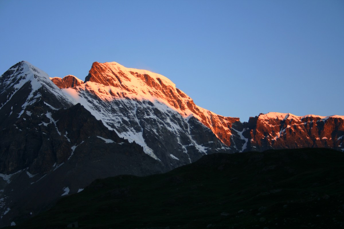
Day 2 Montroc – Balme pass – Albert 1er hut : After breakfast we took a Van with all out gears to Argentire. Start was slightly inauspicious due violent thunderstorm . We waited for the weather to improve and then headed up to the lift to the Tete de Balme. Our walk to the hut began with a gentle stroll through the flower meadows, traversing the slopes towards the Le Tour glacier. Rounding the corner on the Bec du Picheau we got the most amazing view of the Le tour Glacier and its huge waterfalls and seracs, a magnificent site even in the hazy sunshine between the rain showers. After a short walk we took chair lift at Le Tour and our trek started This was relatively easy day we had to walk to Albert 1er hut.The path was relatively easy but quite steep at places. We travelled through lush green Alpine valleys and meadows. The path was very steep towards end and I had to struggle really hard to keep pace with the group.
2 h 30m hike. A : 550 m


Day 3 Albert 1er hut – upper Tour pass – Au Club Alpin: I overslept and took longer to fresh up and have breakfast. The group was waiting for me and we got a bit delayed. Today plan was to reach to Au Club Alpin in Champex. Champex is a small village located in French speaking canton of Valais part of municipality of Orsieres. This is located directly at the foot of Mont Blanc Massif.This is the second day and I was struggling with my oversized rucksack. Andy suggested to strip off all unnecessary items and send it to Zermatt by post. This was the last village before Arolla. The day started climbing Moraine outside hut. Then we had to rope up to cross Col Superior De Tour. Here we cross Swiss border (there was no one to check my passport !) and climb down to Orny hut via Tour pass. We had our Launch here. While we were ascending Col Superior the weather was fine , suddenly we took a turn and we were in the middle of a snow blizzard . It was so severe that I could not see anything not even my hands. We were all roped up and trying to pass the blizzard as quickly as possible.Suddenly my right leg got stuck under a bolder and I could not take it out . I was getting pulled in my rope and no one could hear me because of deafening sound of the storm. Finally I managed to free my leg but two metal clips of my boot got broken. From Orny hut we took Breya chair lift down to Champex. We stayed at Club Alpin beside the lake. Also today we had a refreshing shower after 3 days.
7 h hike. A: 750 m. D : 1000 m

Day 4 Au Club Alpin- Mauvoisin lake – Chanrion hut: The Chanrion Hut is a mountain hut located in the upper Val de Bagnes in the canton of Valais in Switzerland. It lies in an isolated area south of Lac de Mauvoisin at an altitude of 2,462m, at the foot of Pointe d’Otemma.We took a short transfer by bus to Mauvoisin dam / lake.This is the 8th highest dam in the world and 3rd largest arch dam . The height of the reservoir is 250m. This dam was originally build in 1951 – 57 and raised further by another 13.5m in 1991. We were carrying picnic lunch today, bread, crisps , cheese, ham and salami. From here its 4 hour hike through quite meadows to Chanrion hut.
4 h hike. A: 650 m, D : 180 M.
Day 5 Chanrion hut – Chermotane pass – Vignettes hut: The day started working through pleasant meadows at mid altitude. Then we encountered Otemma glacier. We went up following entire length of the glacier (6km) and finally reached to Chermotane pass (3053m) . From mountain pass our next stop was only an hour’s walk away. Behind was the Vignettes hut (3158 m) hanging on the edge of the mountain of the same name. 5 h hike. A: 841m, D : 143M.
Day 6 Vignettes hut – Pigne -d Arolla – Hotel kurhaus: We woke up early morning to have breakfast and then climbed Pigne – d Arolla (3796m). We went back to vignettes pass, then went down to Otemma glacier.We had to go around the rocks at 3189m and crest steep slope of Pigne – d Arolla south flank. It took 3 hours and we summited at around 9 AM. Then we came back to Vignettes hut to have some tea and light snacks and we were off to Arolla village (1998m). This was a long descent first with crampons then mostly rambling path on boulders.
8 h hike. A: 638m, D : 1160M

Day 7 Arolla – Evolene (via Ferrate): Next two days were supposed to be the highlights of Haute route.We were to reach to Bertrol Hut(3311m) today via mountain pass Col de Eveque (3386m). From Betrol Hut we were to ascend to Tete Blanche (3724m) and to discover majestic summits of “seigneurs des Alpes”, some of the most beautiful peaks of Valaisan Alps. Then we were to descent along Stockji glacier under north face of Dent d’Herens and the Matterhorn. Finally we were to climb for another hour to Schonobiel Hut and then it was easy route down to Zermatt from Schonobiel. Unfortunately at Arolla our guide was informed that weather is pretty bad upper ridges of Arolla and there is fair chance of Avalanche. The prediction was weather is not going to improve in next 3 days. Our guide was reluctant to take the risk specifically no one from our group was a seasoned mountaineer. It was also not possible for us to wait in Arolla for 3 days for weather to get better.So we had to cancel our itinerary for last two days. From Arolla we went for village Evolene by bus. In the village our guide new an elderly English couple who invited us for a cup of tea. We left our rucksack in their garage and went for stroll around the village.Six people in our group splited into two subgroup. Me ,Chris and Rona went on for a hike above Evolene through a dense lush green forest and other three went for via Ferrate. Plan was after couple of hours we will go for via Ferrate and they will go for the hike.From parking access to via ferrate is shown towards a cliff. The area has 3 parts, 2 loopholes, 1 scale , 1 lattice. The section is open only from June to December to allow owls to nest in peace. This was pretty uneventful except Scott lost his camera.With a heavy heart I headed for Zermatt for two nights stay. The trek was physically demanding but I enjoyed every bit of it . I wished if I could complete Arolla to Zermatt section . May be someday I will come back again 🙂


